See also
All about Cyprus - Όλα για την Κύπρο
List of cities towns and villages in Cyprus - Κατάλογος δήμων και κοινοτήτων της Κύπρου
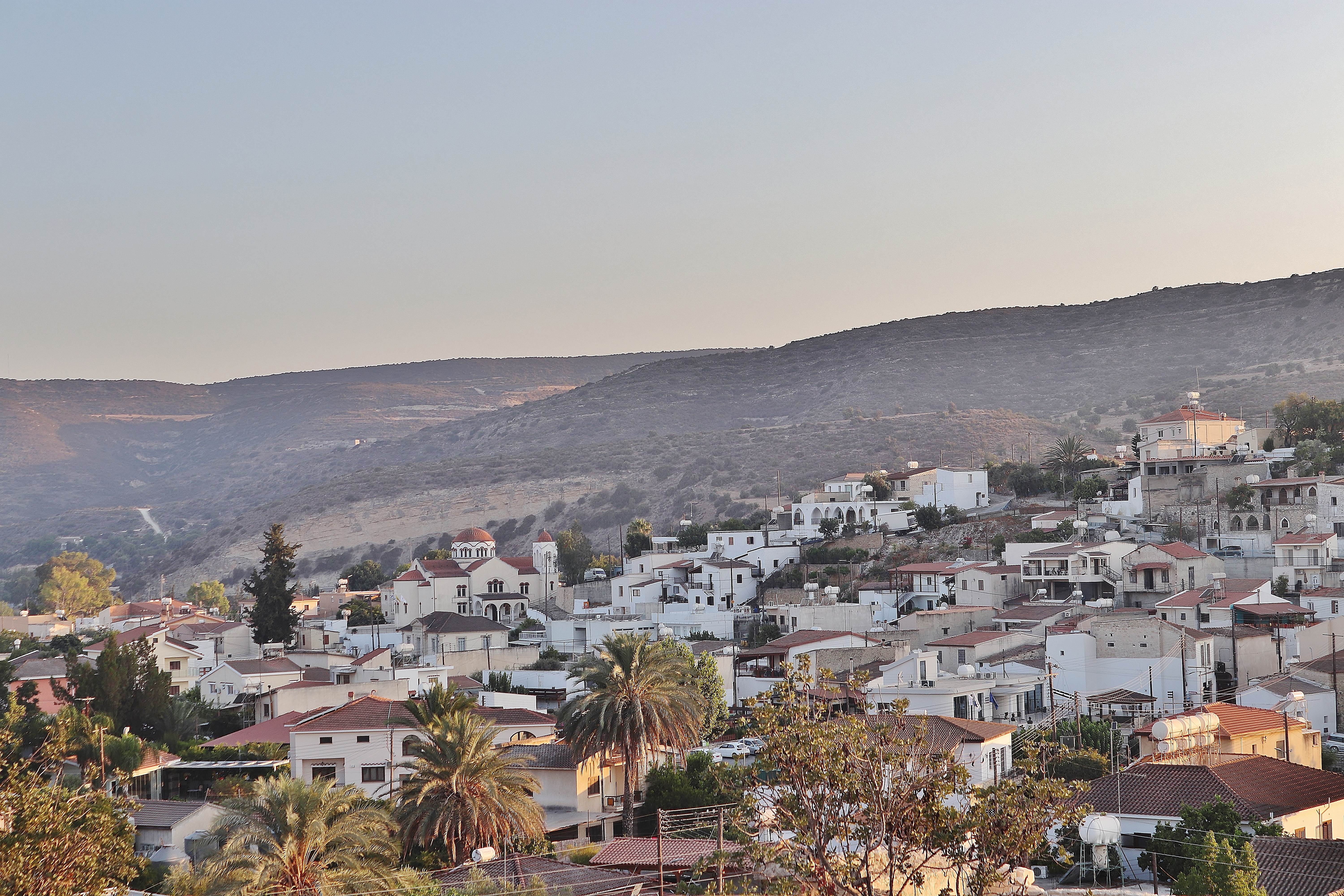
Εκκλησία Αγίου Θεοδώρου στο χωριό Άγιος Θεόδωρος στην επαρχία Λάρνακας -- Cyprus
Photos Agios Theodoros 23/8/2023 by George Konstantinou

Below
in English
Κείμενο του Γιώργου Κωνσταντίνου
Ο Άγιος Θεόδωρος Λάρνακας
Ο Άγιος Θεόδωρος είναι ένα γραφικό χωριό της επαρχίας Λάρνακας, κτισμένο στις όχθες του ποταμού Πεντάσχοινου. Η κοινότητά του καταλαμβάνει μια ιδιαίτερα μεγάλη περιοχή, η οποία εκτείνεται από την ενδοχώρα μέχρι τη νότια ακτή της Κύπρου.
Πρόκειται για ένα χωριό όπου συνδυάζονται το παραδοσιακό αγροτικό τοπίο, η κοιλάδα του Πεντάσχοινου, η φυσική βλάστηση και η θάλασσα. Σύμφωνα με το Κοινοτικό Συμβούλιο, ο Άγιος Θεόδωρος είναι μία από τις μεγαλύτερες κοινότητες της Κύπρου σε έκταση και διαθέτει περίπου 8,5 χιλιόμετρα παραλιακού μετώπου.
Η ονομασία του χωριού
Η ονομασία Άγιος Θεόδωρος προέρχεται από τον πολιούχο Άγιο της κοινότητας. Στο χωριό βρίσκεται ο κεντρικός ναός που είναι αφιερωμένος στον Άγιο Θεόδωρο τον Τήρωνα, με τον οποίο συνδέεται άμεσα η ονομασία του οικισμού.
Η στενή αυτή σχέση ανάμεσα στον πολιούχο και το χωριό αποτελεί χαρακτηριστικό παράδειγμα του τρόπου με τον οποίο η θρησκευτική παράδοση επηρέασε πολλά κυπριακά τοπωνύμια.
Η ιστορία της περιοχής
Ιδιαίτερο ενδιαφέρον παρουσιάζει το γεγονός ότι ο σημερινός Άγιος Θεόδωρος δεν σημειώνεται στους παλαιούς κυπριακούς χάρτες.
Σύμφωνα με την επίσημη ιστορία της κοινότητας, είναι πιθανόν ο σημερινός οικισμός να δημιουργήθηκε από παλαιότερους οικισμούς της γύρω περιοχής. Σε μεσαιωνικούς χάρτες της Κύπρου συναντώνται ονομασίες όπως Anastadia, Xeugalalio, Capno, Vasilopotamo και Pendasino.
Οι αναφορές αυτές δείχνουν ότι, ακόμη και αν το σημερινό χωριό δεν εμφανίζεται με τη σύγχρονη ονομασία του, η ευρύτερη περιοχή είχε οικιστική ιστορία που ανάγεται σε πολύ παλαιότερες εποχές.
Ο ποταμός Πεντάσχοινος
Ο Πεντάσχοινος αποτελεί ένα από τα σημαντικότερα φυσικά χαρακτηριστικά του Αγίου Θεοδώρου και είναι άμεσα συνδεδεμένος με τη γεωγραφία και την ιστορία της κοινότητας.
Ο ποταμός διασχίζει την περιοχή και καταλήγει στη θάλασσα. Ο δρόμος που οδηγεί από το χωριό προς την παραλιακή περιοχή είναι γνωστός ως «Κοιλάδα του Πεντασχοίνου».
Για την προέλευση της ονομασίας Πεντάσχοινος έχουν διασωθεί διάφορες τοπικές παραδόσεις. Μία από αυτές αναφέρει την ύπαρξη ενός τεράστιου φιδιού του ποταμού, μιας «κουφής», που είχε μήκος πέντε σχοινιά. Πρόκειται για λαϊκή παράδοση και όχι για ιστορικά τεκμηριωμένη ετυμολογία, αλλά αποτελεί ενδιαφέρον κομμάτι της τοπικής προφορικής κληρονομιάς.
Το φυσικό τοπίο
Η μεγάλη έκταση της κοινότητας έχει ως αποτέλεσμα τη δημιουργία ενός ιδιαίτερα ποικιλόμορφου τοπίου.
Η περιοχή παρουσιάζει ορεινά και ημιορεινά χαρακτηριστικά, έντονες κλίσεις και μορφολογία, ενώ προς το νότιο τμήμα της εμφανίζονται περισσότερο πεδινές εκτάσεις που καταλήγουν στη θάλασσα.
Η φυσική βλάστηση σχηματίζει ένα μωσαϊκό από μακκία, φρυγανική, παραποτάμια και δασώδη βλάστηση, μαζί με τις καλλιεργημένες εκτάσεις της κοινότητας.
Κατά μήκος της διαδρομής προς την παραλία συναντώνται επίσης σπηλιές, φαράγγια και καλλιέργειες, ενώ οι πορτοκαλιές, μανταρινιές και λεμονιές αποτελούν χαρακτηριστικό στοιχείο του αγροτικού τοπίου.
Η σημασία της περιοχής για την άγρια ζωή
Η φυσική αξία της ευρύτερης περιοχής είναι σημαντική και για την πανίδα της Κύπρου.
Μέρος της έχει καθοριστεί ως Ζώνη Ειδικής Προστασίας (ΖΕΠ) λόγω της σημασίας της για την ορνιθοπανίδα. Σύμφωνα με το Κοινοτικό Συμβούλιο, η περιοχή έχει καθοριστεί για έξι είδη άγριων πουλιών που αναπαράγονται εκεί σε σημαντικούς αριθμούς, καθώς και για μεταναστευτικά πουλιά.
Η παρουσία του ποταμού, των θαμνώνων, της παραποτάμιας βλάστησης, των γεωργικών εκτάσεων και της παράκτιας ζώνης δημιουργεί διαφορετικούς τύπους ενδιαιτημάτων μέσα στα όρια της ίδιας κοινότητας.
Από το χωριό μέχρι τη θάλασσα
Ένα από τα ιδιαίτερα χαρακτηριστικά του Αγίου Θεοδώρου είναι ότι τα διοικητικά του όρια εκτείνονται σε μεγάλη απόσταση προς τα νότια, μέχρι τη Μεσόγειο Θάλασσα.
Η παραλιακή ζώνη του χωριού διαθέτει περίπου 8,5 χιλιόμετρα ακτογραμμής. Με την πάροδο των χρόνων αναπτύχθηκαν στην περιοχή κατοικίες και μεγάλος αριθμός εξοχικών κατοικιών.
Έτσι, μέσα στα όρια της ίδιας κοινότητας συναντά κανείς δύο διαφορετικές όψεις της Κύπρου: το παραδοσιακό χωριό της ενδοχώρας και την παραθαλάσσια περιοχή του Πεντάσχοινου.
Ένα παλαιό μικτό χωριό
Ο Άγιος Θεόδωρος υπήρξε στο παρελθόν μικτό χωριό Ελληνοκυπρίων και Τουρκοκυπρίων. Η παρουσία των δύο κοινοτήτων αποτελεί σημαντικό μέρος της νεότερης κοινωνικής ιστορίας του οικισμού.
Χαρακτηριστική είναι η αναφορά ότι από τα μέσα της δεκαετίας του 1950 πραγματοποιούνταν ανεπίσημοι ποδοσφαιρικοί αγώνες μεταξύ Ελληνοκυπρίων και Τουρκοκυπρίων νέων. Το τότε γήπεδο βρισκόταν κοντά στις όχθες του Πεντάσχοινου.
Η περίοδος αυτή έληξε μετά τα γεγονότα του 1974, όταν οι Τουρκοκύπριοι κάτοικοι εγκατέλειψαν την κοινότητα.
Θρησκευτική και πολιτιστική κληρονομιά
Η περιοχή διαθέτει σημαντική θρησκευτική και πολιτιστική κληρονομιά, με κεντρικό σημείο αναφοράς την Εκκλησία Αγίου Θεοδώρου του Τήρωνος.
Στην ευρύτερη περιοχή υπάρχουν επίσης ξωκλήσια και άλλα θρησκευτικά μνημεία. Ένα από τα νεότερα είναι το ξωκλήσι των Αγίων Τριών Παίδων και του Προφήτη Δανιήλ, το οποίο οικοδομήθηκε το 2004 στην περιοχή προς τον Πεντάσχοινο.
Στην κοινότητα διατηρούνται επίσης στοιχεία της παραδοσιακής αγροτικής ζωής, όπως ο παραδοσιακός ελαιόμυλος, καθώς και άλλα σημεία πολιτιστικού και ιστορικού ενδιαφέροντος.
Ο Άγιος Θεόδωρος σήμερα
Σύμφωνα με τα στοιχεία που δημοσιεύει το Κοινοτικό Συμβούλιο, ο Άγιος Θεόδωρος αριθμεί περίπου 700 κατοίκους, ενώ διαθέτει σχεδόν αντίστοιχο αριθμό εξοχικών κατοικιών, πολλές από τις οποίες βρίσκονται προς την παραλιακή περιοχή.
Η κοινότητα έχει ενταχθεί στο Σύμπλεγμα Βασιλικός–Πεντάσχοινος και έχει λάβει την πιστοποίηση “Colourful Villages of Cyprus” για τον φυσικό πλούτο και την πολιτιστική της κληρονομιά. Έχει επίσης τιμηθεί ως «Πράσινη Κοινότητα της Κύπρου».
Παράλληλα, ο παραδοσιακός πυρήνας, οι αγροτικές δραστηριότητες, η φύση και η παραλιακή περιοχή έχουν συμβάλει στην ανάπτυξη του αγροτουρισμού και του φυσιολατρικού ενδιαφέροντος.
Ένα ιδιαίτερο χωριό της κυπριακής υπαίθρου
Ο Άγιος Θεόδωρος είναι μια κοινότητα όπου συνυπάρχουν ιστορία, παράδοση, γεωργία, φυσικό περιβάλλον και θάλασσα.
Από τον παλαιό πυρήνα του χωριού και την Εκκλησία του Αγίου Θεοδώρου μέχρι τον ποταμό και την κοιλάδα του Πεντάσχοινου, και από τους θαμνώνες και τις καλλιέργειες μέχρι την ακτογραμμή, η περιοχή παρουσιάζει πολλές διαφορετικές όψεις του κυπριακού τοπίου.
Η καταγραφή τέτοιων χωριών, των μνημείων, των παραδόσεων και του φυσικού τους περιβάλλοντος συμβάλλει στη διατήρηση και ανάδειξη της φυσικής και πολιτιστικής κληρονομιάς της Κύπρου.


Text by George Konstantinou
Agios Theodoros, Larnaca
Agios Theodoros is a picturesque village in the Larnaca District, situated along the banks of the Pentashoinos River. The territory of the community covers a particularly large area, extending from the inland countryside all the way to the southern coast of Cyprus.
The village combines the traditional agricultural landscape of rural Cyprus with the Pentashoinos valley, natural vegetation and the Mediterranean coast. According to the Community Council, Agios Theodoros is one of the larger communities of Cyprus in terms of territory and has approximately 8.5 kilometres of coastline.
The Name of the Village
The name Agios Theodoros derives from the patron saint of the community. The principal church of the village is dedicated to Saint Theodoros Tyron (Saint Theodore the Recruit), after whom the settlement was named.
This close relationship between the patron saint and the name of the community is characteristic of many Cypriot villages, where churches and local religious traditions played an important role in the development of place names.
History of the Area
An interesting feature of the history of Agios Theodoros is that the present village does not appear on old maps of Cyprus.
According to the history recorded by the Community Council, the modern settlement may have developed from populations associated with older settlements in the surrounding region. Medieval maps of Cyprus record nearby settlements under names including Anastadia, Xeugalalio, Capno, Vasilopotamo and Pendasino.
These references indicate that although the present village may not appear under its modern name on early maps, the wider region has a much longer history of human settlement.
The Pentashoinos River
The Pentashoinos River is one of the most important natural features of Agios Theodoros and is closely connected with both the geography and history of the community.
The river passes through the area and continues towards the Mediterranean Sea. The route connecting the inland village with its coastal territory follows the beautiful Pentashoinos Valley.
Various local traditions survive concerning the origin of the name Pentashoinos. One tells of an enormous snake associated with the river that was said to measure five ropes in length. This is a piece of local folklore rather than a historically established explanation of the place name, but it forms an interesting part of the oral tradition of the community.
The Natural Landscape
Because of the extensive territory of the community, Agios Theodoros contains a remarkably varied landscape.
The northern and inland areas have hilly and semi-mountainous characteristics, steep slopes and valleys, while towards the south the terrain gradually becomes lower and eventually reaches the Mediterranean coast.
Natural vegetation forms a mosaic of maquis, phrygana, riparian and other Mediterranean vegetation, interspersed with agricultural land.
Along the route towards the coast there are also caves, gorges and cultivated areas. Orange, mandarin and lemon trees are characteristic elements of the agricultural landscape, particularly attractive during the flowering season.
Importance for Wildlife
The wider area of Agios Theodoros is also important for the wildlife of Cyprus.
Part of the region has been designated as a Special Protection Area (SPA) because of its importance for wild birds. The area supports breeding bird species as well as migratory birds passing through Cyprus.
The combination of river habitats, riparian vegetation, Mediterranean scrubland, cultivated fields and coastal habitats creates considerable ecological diversity within the boundaries of a single community.
The Pentashoinos valley therefore has significance not only for the cultural history of Agios Theodoros but also for the natural heritage and biodiversity of Cyprus.
From the Village to the Sea
One of the most distinctive characteristics of Agios Theodoros is that its administrative territory extends for a considerable distance southwards until it reaches the Mediterranean Sea.
The coastal section of the community includes approximately 8.5 kilometres of coastline. Over the years, residential and holiday development has also taken place in this part of the community.
Agios Theodoros therefore presents two very different aspects of Cyprus within the boundaries of the same village: the traditional inland settlement and the coastal landscape associated with the lower Pentashoinos valley.
A Former Mixed Village
Agios Theodoros was historically a mixed Greek Cypriot and Turkish Cypriot village, an important part of its modern social history.
The two communities shared the village and its surrounding countryside for many years. One interesting detail preserved in the local history concerns informal football matches played between young Greek Cypriots and Turkish Cypriots from the mid-1950s onwards. The football ground of that period was situated near the banks of the Pentashoinos River.
This period of coexistence came to an end following the events of 1974, when the Turkish Cypriot inhabitants left the community.
The history of Agios Theodoros therefore reflects some of the wider historical and demographic changes experienced by many Cypriot villages during the 20th century.
Religious and Cultural Heritage
Agios Theodoros possesses an interesting religious and cultural heritage.
Its principal religious landmark is the Church of Saint Theodoros Tyron Εκκλησία Αγίου Θεοδώρου , situated within the village and closely connected with the identity and name of the community.
Several chapels and other places of worship are found throughout the wider area. These religious sites reflect the close relationship that traditionally existed between the inhabitants of rural Cyprus, agriculture, local saints and the surrounding countryside.
The community also preserves elements associated with traditional rural life, including an old olive mill, together with other historical and cultural sites.
Local place names are another important part of this heritage. Many have survived for generations and preserve memories connected with the landscape, agricultural activities, former settlements, traditions and events from the history of the region.
Agios Theodoros Today
According to information published by the Community Council, Agios Theodoros has approximately 700 permanent inhabitants, while there is also a considerable number of holiday homes, particularly towards the coastal area.
The community forms part of the Vasilikos–Pentashoinos regional complex and has promoted its natural landscape, cultural heritage and rural character as important elements of its identity.
Agios Theodoros has also received recognition through the “Colourful Villages of Cyprus” initiative and has been distinguished as a Green Community of Cyprus.
Its traditional village centre, agricultural activities, natural environment, river valley and coastal area provide opportunities for rural, cultural and nature-based tourism.
A Distinctive Village of Rural Cyprus
Agios Theodoros is a community where history, tradition, agriculture, nature and the sea come together within a single landscape.
From the old village centre and the Church of Saint Theodoros Tyron to the Pentashoinos River and its valley, and from Mediterranean scrub and cultivated fields to the coastline, the area preserves many different aspects of the Cypriot countryside.
Recording villages such as Agios Theodoros, together with their monuments, traditions, place names and natural environment, contributes to the preservation and promotion of the natural and cultural heritage of Cyprus.

