See also
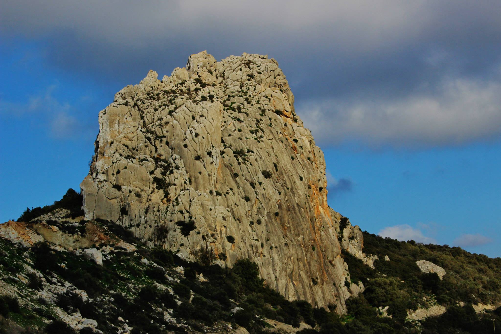
Photos 28/12/2015 by George Konstantinou
Below
in English
Η τοποθεσία Φονιάς μεταξύ Ολύμπου και Καντάρας – Πάνω από την Ακανθού και τις Μάντρες Αμμοχώστου
Κείμενο: Γιώργος Κωνσταντίνου
Η τοποθεσία Φονιάς βρίσκεται στην οροσειρά του Πενταδακτύλου, στην κατεχόμενη επαρχία Αμμοχώστου, στην ορεινή περιοχή πάνω από τα χωριά Ακανθού και Μάντρες. Πρόκειται για ένα εντυπωσιακό βραχώδες σημείο της κορυφογραμμής που εκτείνεται ανάμεσα στον Όλυμπο στα δυτικά και την Καντάρα στα ανατολικά.
Η περιοχή χαρακτηρίζεται από απόκρημνους ασβεστολιθικούς σχηματισμούς, βαθιές χαράδρες, πλαγιές και κορυφές που δημιουργούν ένα από τα πιο άγρια τοπία αυτού του τμήματος της οροσειράς.
Η ύπαρξη της ονομασίας Φονιάς στην περιοχή τεκμηριώνεται και στον επίσημο Complete Gazetteer of Cyprus, ενώ επιστημονική βοτανική δημοσίευση αναφέρει συγκεκριμένα τη θέση “Fonias Kantara–Olympos road”, επιβεβαιώνοντας τη χρήση του τοπωνυμίου στην περιοχή.
Η κορυφογραμμή του Ζυού
Η κορυφογραμμή που συνδέει την περιοχή των Μαντρών με την Ακανθού είναι γνωστή τοπικά ως Ζυός.
Πρόκειται για μια επιβλητική ορεινή ζώνη με συνεχείς βραχώδεις εξάρσεις και φαράγγια. Εκτείνεται από την περιοχή του Ολύμπου προς τα δυτικά μέχρι την Καντάρα στα ανατολικά, σχηματίζοντας το φυσικό ορεινό όριο πάνω από τις πεδινότερες περιοχές της Μεσαορίας.
Ανάμεσα στους βράχους της κορυφογραμμής ξεχωρίζει ο Φονιάς, το όνομα του οποίου συνδέεται με μια παλιά τοπική παράδοση.
Η παράδοση για την ονομασία «Φονιάς»
Σύμφωνα με την τοπική παράδοση, όπως έχει καταγραφεί από τον Yiannis Kypri, η ονομασία Φονιάς συνδέεται με την ιστορία ενός μοναχού που καταδιωκόταν από Σαρακηνούς.
Ο μοναχός, προσπαθώντας να ξεφύγει, ανέβηκε στην κορυφή ενός απόκρημνου βράχου. Οι διώκτες του όμως συνέχισαν να τον πλησιάζουν και, όταν πλέον δεν είχε άλλη διέξοδο, προσευχήθηκε στην Παναγία για να σωθεί.
Τότε πήδηξε από τον βράχο προς την απέναντι πλευρά.
Το «Καλοήριν»
Κατά την παράδοση, ο μοναχός κατάφερε με θαυμαστό τρόπο να επιβιώσει από το άλμα και να προσγειωθεί στον απέναντι λόφο.
Ο λόφος αυτός έμεινε γνωστός ως «Καλοήριν», ονομασία που συνδέεται με τον καλόγερο της παράδοσης.
Ο μοναχός συνέχισε την πορεία του μέχρι που βρήκε μια πηγή νερού. Εκεί, σύμφωνα πάντα με την παράδοση, έκτισε μοναστήρι αφιερωμένο στην Παναγία ως ένδειξη ευγνωμοσύνης για τη σωτηρία του.
Η Παναγία του Τοχνιού
Το μοναστήρι που συνδέει η παράδοση με τον μοναχό αναφέρεται ως Παναγία του Τοχνιού.
Η ιστορία αυτή αποτελεί μέρος της προφορικής παράδοσης της περιοχής και όχι τεκμηριωμένο ιστορικό περιστατικό. Γι' αυτό πρέπει να αντιμετωπίζεται ως τοπικός θρύλος που επιχειρεί να ερμηνεύσει την προέλευση των τοπωνυμίων Φονιάς και Καλοήριν.
Η τύχη των Σαρακηνών
Η παράδοση συνεχίζει αναφέροντας ότι οι Σαρακηνοί που καταδίωκαν τον μοναχό προσπάθησαν να τον μιμηθούν.
Πήδηξαν και αυτοί από τον απόκρημνο βράχο, όμως, σε αντίθεση με τον μοναχό, έπεσαν στο κενό και σκοτώθηκαν.
Από αυτό το περιστατικό, σύμφωνα με τον θρύλο, ο βράχος απέκτησε την ονομασία «Φονιάς».
Ένα ιδιαίτερα απόκρημνο τοπίο
Η μορφολογία της περιοχής βοηθά να κατανοήσει κανείς πώς δημιουργήθηκε μια τέτοια παράδοση.
Οι απότομοι βράχοι, οι γκρεμοί και οι χαράδρες αποτελούν κυρίαρχα χαρακτηριστικά του τοπίου. Από ψηλά ανοίγεται εκτεταμένη θέα προς τις γύρω ορεινές και πεδινές περιοχές, ενώ προς τα ανατολικά δεσπόζει η περιοχή της Καντάρας.
Η γεωλογική μορφή της οροσειράς του Πενταδακτύλου έχει δημιουργήσει πολλά τέτοια εντυπωσιακά φυσικά σημεία, τα οποία συχνά συνδέθηκαν στη λαϊκή παράδοση με θρύλους και ιστορίες.
Η φυσική σημασία της περιοχής
Ο Φονιάς δεν παρουσιάζει ενδιαφέρον μόνο ως τοπωνύμιο και ως μέρος της λαϊκής παράδοσης. Η περιοχή έχει και βοτανικό ενδιαφέρον.
Σε επιστημονική εργασία με συμπληρωματικές καταγραφές για τη χλωρίδα της Κύπρου αναφέρεται ρητά η θέση Fonias, Kantara–Olympos road ως μία από τις βοτανικές θέσεις της συγκεκριμένης φυτογεωγραφικής περιοχής. Στην ίδια δημοσίευση αναφέρονται επίσης θέσεις πάνω από την Ακανθού και τις Μάντρες Αμμοχώστου.
Η καταγραφή αυτή είναι ιδιαίτερα χρήσιμη, επειδή αποτελεί ανεξάρτητη επιστημονική επιβεβαίωση του τοπωνυμίου και της γεωγραφικής του σύνδεσης με τον δρόμο Καντάρας–Ολύμπου.
Ο Φονιάς και τα τοπωνύμια της Κύπρου
Τα παλιά τοπωνύμια αποτελούν σημαντικό μέρος της ιστορικής και πολιτιστικής γεωγραφίας της Κύπρου.
Ονόματα όπως Φονιάς και Καλοήριν δεν προσδιορίζουν απλώς σημεία πάνω στον χάρτη. Συχνά διατηρούν ιστορίες, παραδόσεις, γεγονότα ή αντιλήψεις ανθρώπων που έζησαν στην περιοχή πριν από πολλές γενιές.
Στην περίπτωση του Φονιά, το όνομα του βράχου έχει συνδεθεί με μια δραματική ιστορία καταδίωξης, σωτηρίας και θανάτου, η οποία μεταδόθηκε μέσα από την τοπική παράδοση.
Η περιοχή σήμερα
Ο Φονιάς, όπως και ολόκληρη η περιοχή της Ακανθούς, των Μαντρών και της Καντάρας, βρίσκεται από το 1974 υπό τουρκική κατοχή.
Το φυσικό τοπίο, ωστόσο, παραμένει ένα σημαντικό κομμάτι της γεωγραφικής και φυσικής κληρονομιάς της Κύπρου. Οι βραχώδεις κορυφές, τα φαράγγια και τα παλιά τοπωνύμια διατηρούν τη μνήμη ενός τοπίου που ήταν στενά συνδεδεμένο με τις κοινότητες της περιοχής.
Συνοπτικά στοιχεία
Ονομασία: Φονιάς
Περιοχή: Μεταξύ Ολύμπου και Καντάρας
Επαρχία: Αμμόχωστος, Κύπρος
Κοντινά χωριά: Ακανθού και Μάντρες
Οροσειρά: Πενταδάκτυλος
Κορυφογραμμή: Γνωστή τοπικά ως Ζυός
Χαρακτήρας τοπίου: Απόκρημνοι βράχοι, κορυφές, πλαγιές και φαράγγια
Τοπική παράδοση: Η ονομασία Φονιάς συνδέεται με την καταδίωξη ενός μοναχού από Σαρακηνούς
Σχετικό τοπωνύμιο: Καλοήριν
Θρησκευτική παράδοση: Συνδέεται με την Παναγία του Τοχνιού
Επιστημονική τεκμηρίωση τοπωνυμίου: Η θέση Fonias, Kantara–Olympos road αναφέρεται σε επιστημονική βοτανική βιβλιογραφία.
Σημερινή κατάσταση: Περιοχή υπό τουρκική κατοχή από το 1974
Ιδιαίτερο ενδιαφέρον: Συνδυάζει το εντυπωσιακό φυσικό τοπίο του Πενταδακτύλου με παλιά κυπριακά τοπωνύμια, τοπικές παραδόσεις και στοιχεία της φυσικής ιστορίας της περιοχής.


The Locality of Fonias between Olympos and Kantara, above the Occupied Villages of Akanthou and Mandres, Famagusta – Cyprus
The locality known as Fonias lies in the Kyrenia mountain range, in the occupied Famagusta District, in the mountainous area above the villages of Akanthou and Mandres. It is an impressive rocky location along the mountain ridge extending between Olympos to the west and Kantara to the east.
The landscape is characterised by steep limestone formations, deep ravines, slopes and peaks, creating one of the most rugged landscapes in this part of the mountain range.
The toponym Fonias is documented in the official Complete Gazetteer of Cyprus, confirming that it is an established Cypriot place name.
The Zyos Ridge
The mountain ridge connecting the area of Mandres with Akanthou is locally known as Zyos.
It is an imposing mountainous zone characterised by rocky outcrops, steep slopes and ravines. The wider ridge extends through the mountainous landscape between the Olympos and Kantara areas and dominates the country above the villages on the southern side of the Kyrenia range.
Among its rocky formations is Fonias, a place whose name is associated with an old local tradition.
The Tradition behind the Name “Fonias”
According to local tradition, the name Fonias is connected with the story of a monk who was being pursued by Saracens.
Trying to escape, the monk climbed to the top of a steep rock. His pursuers continued to approach him and, when he realised that there was no other way to escape, he prayed to the Virgin Mary for salvation.
He then jumped from the rock towards the opposite side.
“Kaloirin”
According to the tradition, the monk miraculously survived the leap and reached the hill on the opposite side.
That hill became known as “Kaloirin”, a name associated in the local tradition with the monk.
After escaping his pursuers, the monk continued on his way until he found a spring. According to the story, he later established a monastery dedicated to the Virgin Mary as an expression of gratitude for his deliverance.
Panagia tou Tochniou
The monastery associated by tradition with the monk is referred to as Panagia tou Tochniou.
The story belongs to the oral tradition of the area and should not be presented as a historically verified event. It is a local legend associated with the landscape and with the traditional explanation of the place names Fonias and Kaloirin.
The Fate of the Saracens
The tradition continues with the Saracens attempting to follow the monk by making the same leap.
Unlike the monk, however, they fell from the steep rock and were killed.
According to the legend, it was this event that gave the rock the name “Fonias”, a Greek word meaning “killer” or “murderer”.
A Dramatic Rocky Landscape
The physical character of the area makes it easy to understand how such a dramatic legend could have developed.
Steep limestone cliffs, rocky peaks and deep ravines dominate the landscape. From the higher ground there are extensive views over the surrounding mountains and plains, while the Kantara area dominates the landscape farther east.
The geology of the Kyrenia range has produced numerous impressive cliffs and unusual rock formations, many of which became associated with traditional stories and local place names over the centuries.
Natural and Botanical Interest
Fonias is also of interest from a natural-history perspective.
The mountainous zone between Kantara and Olympos, including the country above Akanthou and Mandres, contains characteristic habitats of the eastern part of the Kyrenia range.
The combination of limestone cliffs, rocky slopes, ravines and relatively inaccessible areas provides a variety of conditions for native plants and wildlife.
The preservation of old locality names is particularly useful in natural-history research because historical botanical and zoological records frequently identify specimens by traditional place names rather than by modern coordinates.
Fonias and the Place Names of Cyprus
Traditional place names form an important part of the historical and cultural geography of Cyprus.
Names such as Fonias and Kaloirin are more than simple geographical labels. They can preserve memories, stories and traditions associated with people who lived and travelled through these landscapes generations ago.
In the case of Fonias, the dramatic character of the cliffs became connected with a story of pursuit, miraculous escape and death, which survived through local oral tradition.
The official recording of traditional Cypriot toponyms is particularly important because it preserves the historical geographical identity of places that might otherwise gradually disappear from collective memory. The official Gazetteer of Cyprus documents Fonias among the island's traditional place names.
The Wider Area of Kantara and Mandres
The surrounding landscape contains numerous old Cypriot toponyms. The official Gazetteer, for example, records Kantara and Mandres among the traditional names associated with this part of Cyprus.
These names reflect the long relationship between local communities and the mountainous landscape. Springs, cliffs, fields, ravines, peaks and grazing areas were traditionally given individual names, creating a detailed geographical vocabulary known to the inhabitants of nearby villages.
The Area Today
Fonias, like the wider area of Akanthou, Mandres and Kantara, has been under Turkish occupation since 1974.
Nevertheless, its landscape and traditional place names remain part of the geographical, cultural and natural heritage of Cyprus.
The rocky peaks, ravines and old toponyms preserve the memory of a landscape that for generations was closely connected with the communities living beneath the mountains.
Summary
Name: Fonias
Location: Between Olympos and Kantara
District: Famagusta, Cyprus
Nearby villages: Akanthou and Mandres
Mountain range: Kyrenia mountain range
Local ridge name: Zyos
Landscape: Limestone cliffs, rocky peaks, steep slopes and ravines
Local tradition: The name Fonias is associated with the legend of a monk pursued by Saracens
Related place name: Kaloirin
Religious tradition: Associated with Panagia tou Tochniou
Historical character of the story: Local oral tradition rather than a verified historical event
Toponymic documentation: Fonias is recorded as a Cypriot place name in the official Complete Gazetteer of Cyprus.
Present status: Located in an area under Turkish occupation since 1974
Importance: A distinctive locality of the Kyrenia mountain range combining dramatic limestone scenery, traditional Cypriot place names, local legend and the natural heritage of the mountainous region above Akanthou and Mandres.